

From the heart of the desert to the Arabian Gulf, ADNOC’s Thamama Center of Excellence is harnessing big data, advanced technologies and state-of-the-art imaging techniques to gather critical information from Abu Dhabi’s subsurface.
Spearheading the world’s largest 3D seismic survey of its kind, our Thamama experts are creating high-resolution 3D images of the emirate’s subsurface to model and identify geological formations and find Abu Dhabi’s untapped lower carbon intensity resources as well as rock formations to store carbon dioxide safely and securely.
ADNOC’s 3D seismic survey is being conducted in three geographic areas.
We use special tools and techniques to gather information about resources hidden in the rock beneath our feet, including broadband frequency vibrator trucks to send soundwaves deep into the rock. Upon reflection of these waves from the rock below, data is obtained and gathered, and sent to our experts for detailed analysis to ultimately gain a better understanding of the UAE’s desert subsurface.
We acquire subsurface data from the UAE’s marine territory through the creation of soundwaves launched from seismic vessels. Like onshore, these waves permeate rock layers, where they are reflected to the seafloor. Highly sensitive ocean bottom nodes allow ADNOC to pick these signals up and, through detailed data analysis, gain a better understanding of the subsurface structures and potential resources.
Transition Zones
In seismic surveying, transition zones are defined as areas beneath the ground where the velocity of seismic waves change rapidly, making it more difficult to interpret the seismic data. However, ADNOC’s highly advanced seismic and data processing techniques help improve imaging and reduce uncertainty within these zones. The data acquired result in more accurate subsurface characterization for more effective exploration.
By 2024, ADNOC’s one-of-a-kind program, launched in 2018, will survey an area of 85,000 km2. Our accelerated approach to large-scale surveying is a testament to the company’s ability to fast-track insights and results, and future-proof its business as a responsible and reliable energy provider to customers here in the UAE and around the world.
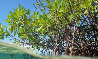
Across our seismic operations we strive to minimize environmental impact. We work with the Environmental Agency – Abu Dhabi (EAD) to mitigate the impact of our operations on the marine ecosystem, where part of our 3D survey is being conducted. We ensure that the survey procedures are compatible with stringent environmental requirements and report important marine life sightings such as dugongs, turtles and dolphins to the EAD. We equally take detailed measures to protect onshore biodiversity and minimize impact on flora and fauna during the survey.
We conduct baseline surveys 6 months apart to identify vulnerable species and habitats, establish, where required, exclusion zones based on risk assessments and monitor these with the support of a robust geofencing system so we avoid potential impact on the environment. Continuous surveillance is also done during seismic acquisition.